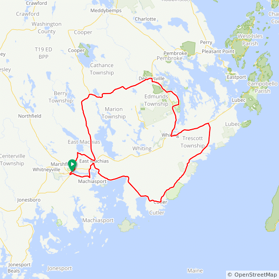
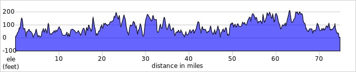
Saturday, 75-mile Route:
The 75-mile Saturday long route heads out of Machias, crosses the tidal Machias River at Bad Little Falls, and then turns past the University of Maine at Machias on the less-traveled Route 92. We’ll head into Machiasport (the center of shipbuilding in times past), over the East Machias River to Route 191, and through Dogtown on our way to the coastal fishing village of Cutler. Along the way, you will catch ocean views of Holmes Bay and Little Machias Bay. You will also notice a large array of towers and cables—a U.S. Navy low-frequency radio communication facility for contacting submarines. The route grows more remote after leaving Cutler, with very few houses to be seen, and views of the classic eastern Maine coastal forest, heath, bog, and wetlands. More ocean views await as the route passes Moose Cove and Bailey’s Mistake in South Trescott. Legend has it that Captain Bailey thought he was reaching Lubec when he turned his ship full of lumber into this cove and ran aground on a foggy night in 1830.
Turning away from the coast on a briefly busy stretch of road, we will pedal into Whiting. As we pass Cobscook Bay State Park, the remote back road here gives beautiful views of Whiting Bay. The route rejoins Route 1 for a couple of miles before we turn left and drop down to cross the Dennys River into Dennysville. We will follow the less-traveled Route 86 (it only has about 10 houses!) for about 10 miles, before turning south for the home stretch. A few more moderate hill climbs will greet you, but a long downhill will welcome you back into Machias.
Mileage: 75 mi // Elevation Gain: 3,330 ft.
Click here for the Ride with GPS route map and GPX file
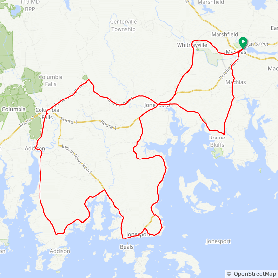
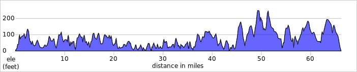
Sunday, 65-mile Route:
The 65-mile Sunday route heads west out of Machias down Route 1, past Bad Little Falls State Park and UMaine Machias. We’ll only be on this busy road momentarily, as we will turn left onto rural Kennebec Street, where forests, farms, and fields will surround your ride. Turning into Roque Bluffs State Park, you’ll get a view of Sanford Cove and the ocean before heading into Jonesboro. There is an optional deviation off the main road onto Kelley Point Road with great ocean views. Rejoining Route 187, we pass through the town of Jonesport, with its busy harbor full of lobster boats and views of Beals and a host of other islands. Heading north, we come to an especially beautiful section of backroads that loops around and passes through the town of Addison before crossing over the West Branch of the Pleasant River. The route goes through Columbia Falls and crosses Route 1 again to head up Centerville Road into spectacular blueberry barren country. After a 10-mile stretch, we descend back to Jonesboro on Route 1 in and out of Whitneyville. Then it’s just another four miles ‘til we ride down Main Street through Machias and arrive at the finish.
Mileage: 65 mi // Elevation Gain: 2,684 ft.
Click here for the Ride with GPS route map and GPX file
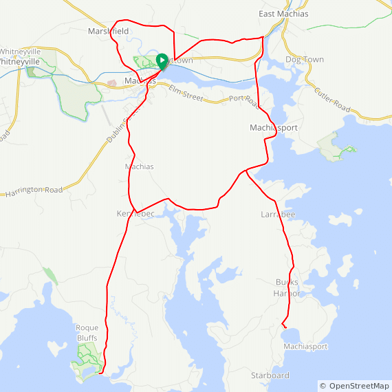
Saturday & Sunday, 35-mile Route:
The 35-mile route starts through downtown Machias and then turns north up Route 192 to Marshfield, making a right turn on Church Street at the Maine Sea Salt Company before joining Marshfield Ridge Road. After some moderate climbing, you’ll make a right on Hadley Lake Road for a nice one-mile downhill back into Hoyttown, with a sharp left turn onto Scotts Hill Road before another climb and a one-mile downhill to East Machias. The route makes a sharp right and then veers off on Rum Road in Machiasport, where you cross over the Mill Creek Bridge and get a view of the tidal Machias River. There are plenty of river and bay views for the next several miles, as the route passes Machias State Park and the Fort O’Brien Historic Site before an optional (but not to be missed!) five-mile out-and-back to spectacular Jasper Beach. Jasper Beach is a truly unique barrier beach, with polished jasper stones of all colors, shades, and patterns!
The route then turns west on Kennebec Street, a beautiful backroad with views of saltwater farms and fields. The route gives you another optional four-mile out-and-back to Roque Bluffs State Park, which has amazing views of Englishman Bay and a maze of ocean islands. Rejoining the main road, it’s another few miles of farms and fields until we meet up with Route 1 for the last stretch into Machias, passing by Bad Little Falls Park as we enter town.
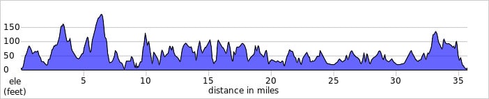
Mileage: 35 mi // Elevation Gain: 1,540 ft.
Click here for the Ride with GPS route map and GPX file